
Keyword
protected area
15 record(s)
Type of resources
Available actions
Topics
Keywords
Contact for the resource
Provided by
Years
Formats
Representation types
Update frequencies
Status
Scale
panaceaKeywords
GEMET keywords
-
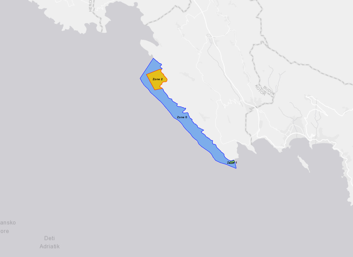
The layer shows the location of Platamuni, first Marine Protected Area in Montenegro which was declared on International Mother Earth Day, 22 April 2021. The Nature Park "Platamuni" is accommodated in the northwest part of the coastal waters in Montenegro, including associated coastline between the Cape Žabica in the northwest and Cape Platamuni in southeast near the beach Ploče. The main reason for proclaiming this first MPA in Montenegro is protecting its ecologically important marine and coastal species and habitats. The Platamuni area is characterized by its main marine cave at the south of Bigova, with at its entrance an extraordinary development of bio-constructions. It also hosts a vast Posidonia oceanica meadow on rock at the western side of Greben Kalafat, continuing by deep coralligenous assemblages on rock. The distribution of caves along the coastline ranges three protected areas: - Zone 0. Platamuni granica zasticenog podrucja - Zone 1. Platamuni II zona zastite morski dio Rt Platamuni - Zone 2. Platamuni II zona zastite morski dio This particular area has benefited in recent years from the support of UNEP/MAP-SPA/RAC, notably through regional projects on marine and coastal protected areas and key habitats mapping in the Mediterranean.
-
Heritage is our legacy from the past, what we live with today, and what we pass on to future generations. Our cultural and natural heritage are both irreplaceable sources of life and inspiration. The United Nations Educational, Scientific and Cultural Organization (UNESCO) seeks to encourage the identification, protection and preservation of cultural and natural heritage around the world considered to be of outstanding value to humanity. This is embodied in an international treaty called the Convention concerning the Protection of the World Cultural and Natural Heritage, adopted by UNESCO in 1972. What makes the concept of World Heritage exceptional is its universal application. World Heritage sites belong to all the peoples of the world, irrespective of the territory on which they are located. The natural marine heritage is recollected into MAPAMED which is a cartographic database of key information on Mediterranean Marine Protected Areas (MPAs) potential Other Effective área-based Conservation Measure (OECMs), and more broadly on sites of interest for marine conservation. It is developed and administered jointly by UNEP/MAP-SPA/RAC and the MedPAN Association. For detailed information, please consult the MAPAMED user manual (April 2021 version).
-
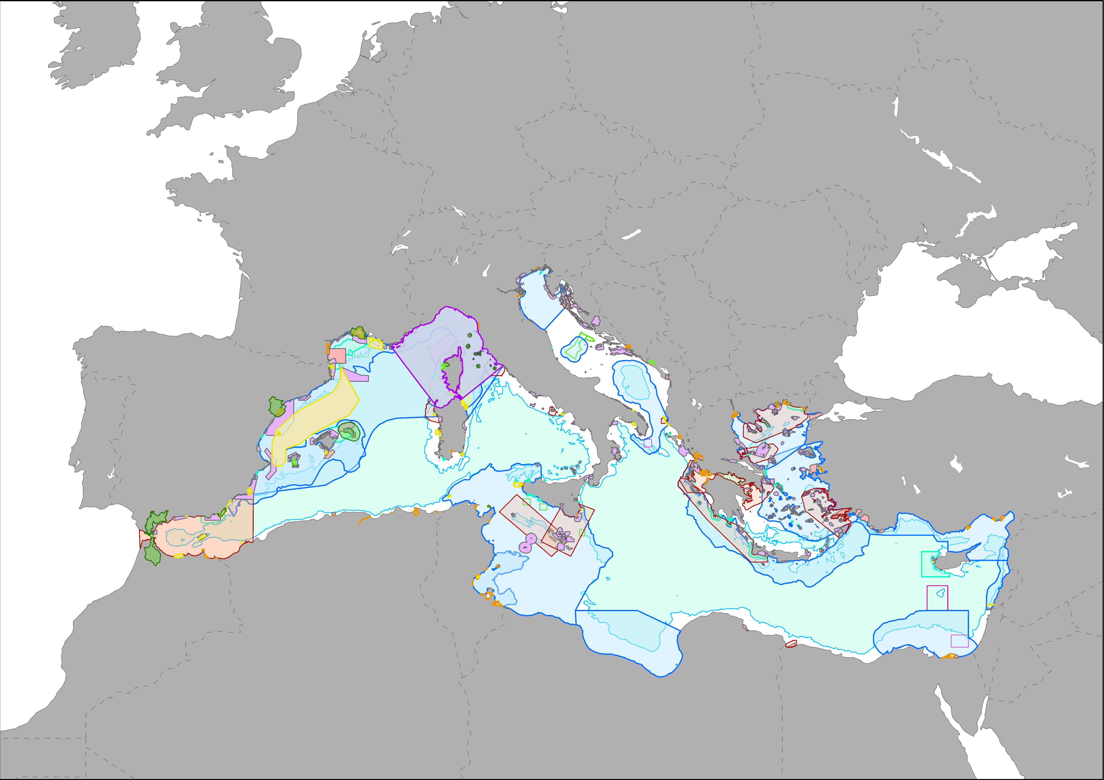
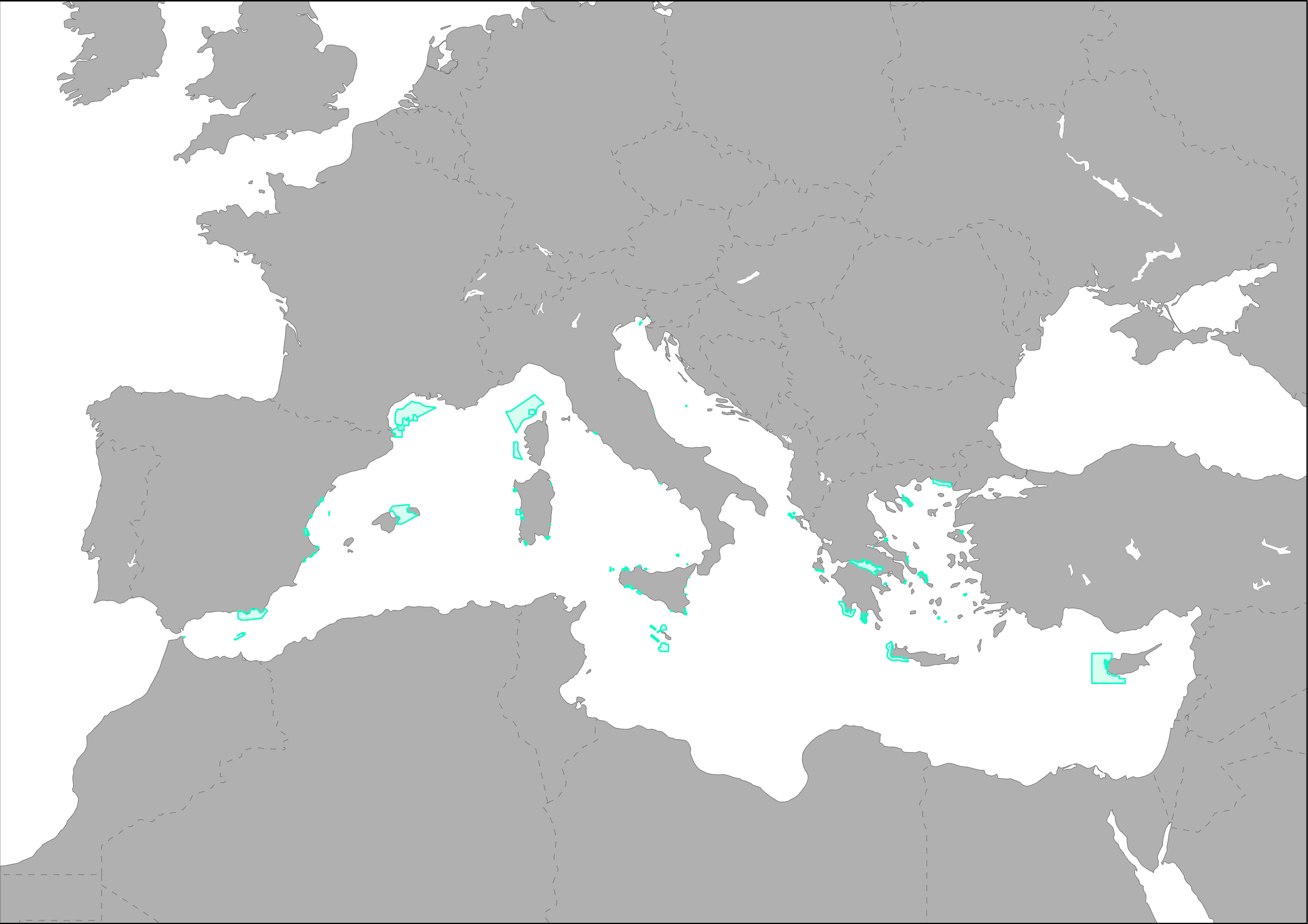
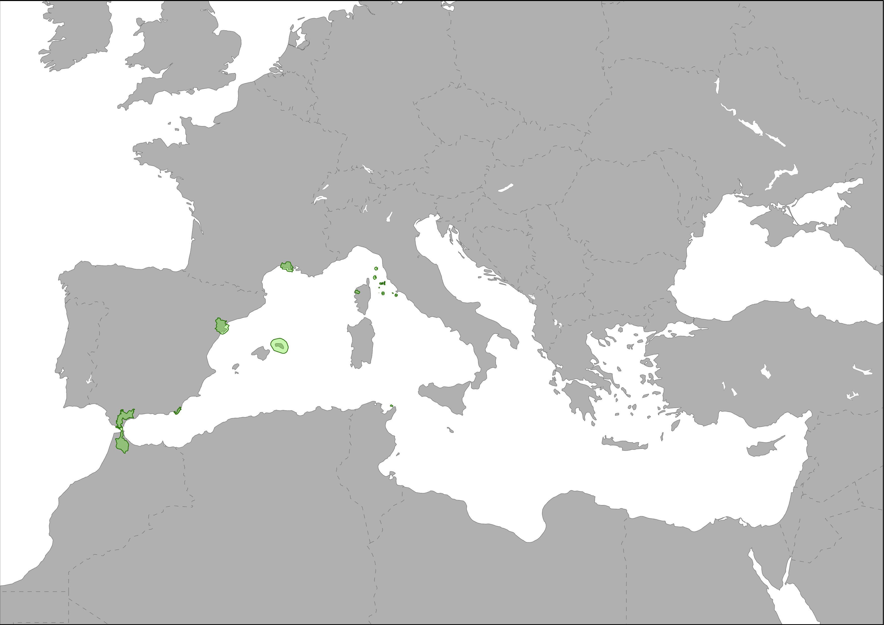
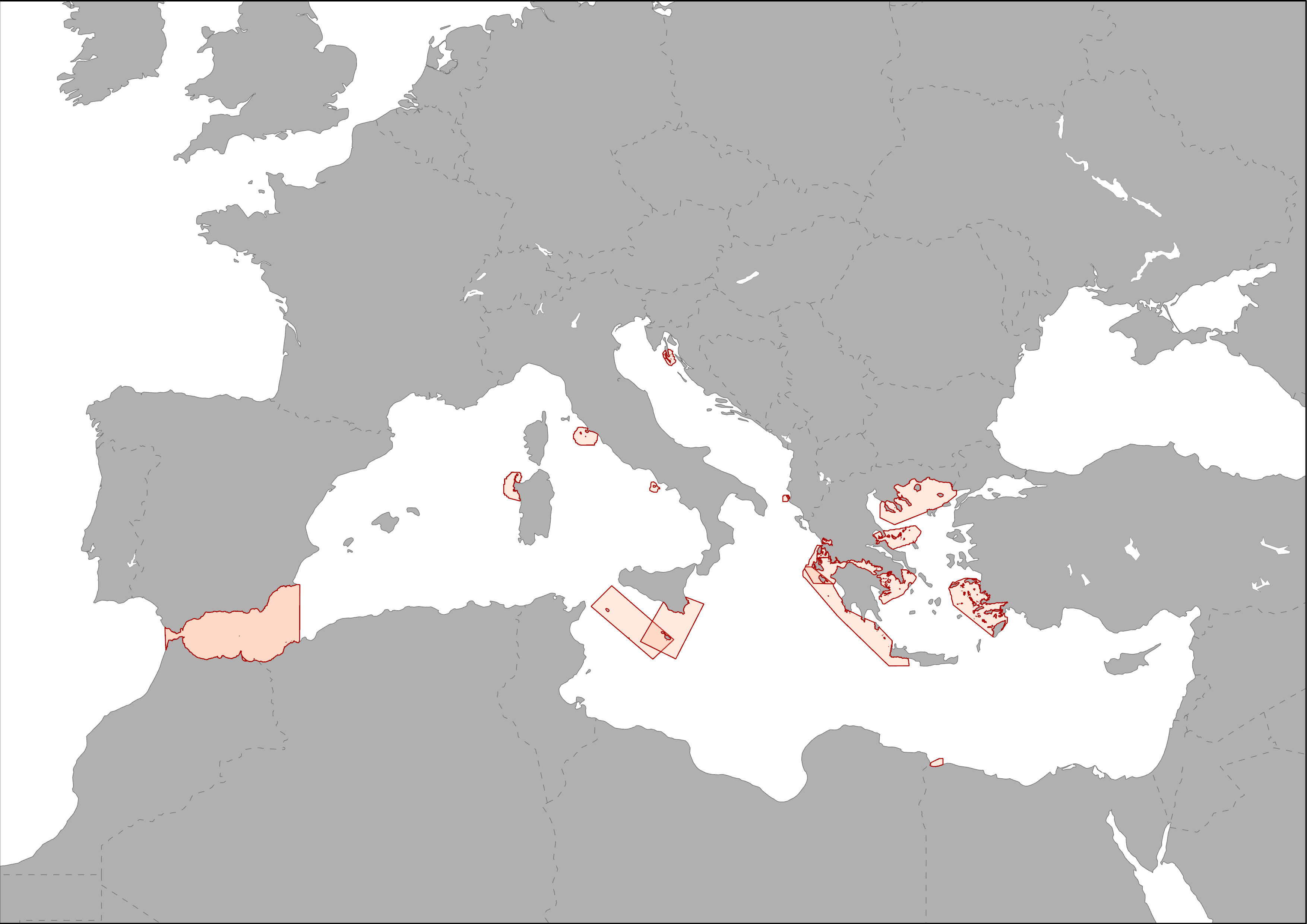
MAPAMED (MArine Protected Areas in the MEDiterranean) is a cartographic database of key information on Mediterranean Marine Protected Areas (MPAs), potential Other Effective area-based Conservation Measure (OECMs), and more broadly on sites of interest for marine conservation. It is developed and administered jointly by UNEP/MAP-SPA/RAC and the MedPAN Association. For detailed information, please consult the MAPAMED user manual (April 2021 version).
-
The EU has established a robust and ambitious policy framework to address the multiple challenges facing its marine environment and to ensure a more sustainable ecosystem-based approach to the use of its marine resources. The Habitats and Birds Directives, along with the Marine Strategy Framework Directive, are the environmental pillar of the wider Integrated Maritime Policy. They are also at the heart of the EU’s contribution to international efforts, including the four Regional Seas Conventions (HELCOM, OSPAR, Barcelona, Black Sea) and the Ocean Governance agenda. The total coverage of EU seas covered by marine protected areas has more than doubled in the last six years, primarily due to the expansion of the Natura 2000 network – the largest coordinated network of conservation areas in the world. The Habitats Directive lists nine marine habitat types and 16 species for which marine site designation is required, whilst the Birds Directive lists a further 60 bird species whose conservation requires marine site protection. To date (end 2018), more than 3150 marine Natura 2000 sites have been designated, which cover almost 10% of the total EU marine area (over 550,000 km2). These areas are recollected into MAPAMED which is a cartographic database of key information on Mediterranean Marine Protected Areas (MPAs) potential Other Effective área-based Conservation Measure (OECMs), and more broadly on sites of interest for marine conservation. It is developed and administered jointly by UNEP/MAP-SPA/RAC and the MedPAN Association. For detailed information, please consult the MAPAMED user manual (April 2021 version).
-
The EU has established a robust and ambitious policy framework to address the multiple challenges facing its marine environment and to ensure a more sustainable ecosystem-based approach to the use of its marine resources. The Habitats and Birds Directives, along with the Marine Strategy Framework Directive, are the environmental pillar of the wider Integrated Maritime Policy. They are also at the heart of the EU’s contribution to international efforts, including the four Regional Seas Conventions (HELCOM, OSPAR, Barcelona, Black Sea) and the Ocean Governance agenda. The proposed sites are recollected into MAPAMED which is a cartographic database of key information on Mediterranean Marine Protected Areas (MPAs) potential Other Effective área-based Conservation Measure (OECMs), and more broadly on sites of interest for marine conservation. It is developed and administered jointly by UNEP/MAP-SPA/RAC and the MedPAN Association. For detailed information, please consult the MAPAMED user manual (April 2021 version).
-
Biosphere Reserve consists of a dynamic and interactive network of sites of excellence. It fosters the harmonious integration of people and nature for sustainable development through participatory dialogue; knowledge sharing; poverty reduction and human well-being improvements; respect for cultural values and society’s ability to cope with change - thus contributing to the 2030 Agenda and the Sustainable Development Goals (SDGs). Accordingly, the Network is one of the main international tools to develop and implement sustainable development approaches in a wide array of contexts. The Network of Biosphere Reserves promotes North-South and South-South collaboration and represents a unique tool for international co-operation through sharing knowledge, exchanging experiences, building capacity and promoting best practices. These areas are recollected into MAPAMED which is a cartographic database of key information on Mediterranean Marine Protected Areas (MPAs) potential Other Effective área-based Conservation Measure (OECMs), and more broadly on sites of interest for marine conservation. It is developed and administered jointly by UNEP/MAP-SPA/RAC and the MedPAN Association. For detailed information, please consult the MAPAMED user manual (April 2021 version).
-

A Fisheries Restricted Area (FRA) is a geographically defined area in which some specific fishing activities are temporarily or permanently banned or restricted in order to improve the exploitation patterns and conservation of specific stocks as well as of habitats and deep-sea ecosystems. In the Mediterranean and the Black Sea, 1,760,000 km2 of sea habitats are protected by nine FRAs established by the GFCM. This includes one large deep-water FRA (1,730,000 km2) in which the use of towed dredges and trawl nets in all waters deeper than 1000 metres is banned to protect deep-sea benthic habitats. These areas are recollected into MAPAMED which is a cartographic database of key information on Mediterranean Marine Protected Areas (MPAs) potential Other Effective área-based Conservation Measure (OECMs), and more broadly on sites of interest for marine conservation. It is developed and administered jointly by UNEP/MAP-SPA/RAC and the MedPAN Association. For detailed information, please consult the MAPAMED user manual (April 2021 version).
-

The Marine Protected Area Protection Framework (MaPAF; Rodríguez-Rodríguez et al., 2016) was adapted to update progress on the protection of Pelagos Sanctuary marine biodiversity. Accordingly, protection was conceived as an additive process entailing two complementary factors: 1. Legal protection and 2. Managerial protection. Legal protection was assessed through two indicators: 1.1. Legal designation (this specific layer), contributing to protection coverage targets, and 1.2. Regulation stringency, contributing to strict protection targets. Managerial protection was assessed via two indicators: 2.1. Existence of a management authority for the site, and 2.2. Existence of a management plan that is fully implemented. Both indicators are expected to contribute to effective Marine Protected Areas & Other Effective Area-Based Conservation Measures (OECMs) management targets. Thus, a site can be legally protected (typically, an MPA), by management measures (e.g. an OECM), attaining different degrees of conservation to their biodiversity. Therefore, a site that has been endowed a stringent legal designation category which has an appointed managerial authority that fully implements the site’s management plan is assumed to have greater protection than a site with opposite characteristics.
-
The Marine Protected Area Protection Framework (MaPAF; Rodríguez-Rodríguez et al., 2016) was adapted to update progress on the protection of Pelagos Sanctuary marine biodiversity. Accordingly, protection was conceived as an additive process entailing two complementary factors: 1. Legal protection and 2. Managerial protection. Legal protection was assessed through two indicators: 1.1. Legal designation, contributing to protection coverage targets, and 1.2. Regulation stringency, contributing to strict protection targets. Managerial protection was assessed via two indicators: 2.1. Existence of a management authority for the site, and 2.2. Existence of a management plan that is fully implemented (this layer). Both indicators are expected to contribute to effective Marine Protected Areas & Other Effective Area-Based Conservation Measures (OECMs) management targets. Thus, a site can be legally protected (typically, an MPA), by management measures (e.g. an OECM), attaining different degrees of conservation to their biodiversity. Therefore, a site that has been endowed a stringent legal designation category which has an appointed managerial authority that fully implements the site’s management plan is assumed to have greater protection than a site with opposite characteristics.
-
ACCOBAMS is working on the identification of new relevant of Cetaceans Critical Habitats (CCH) in the ACCOBAMS area, in order to propose appropriate threats management or spatial management measures. The identification is based on the overlapping of areas of interest for Marine Mammals (IMMAs) and mapping of anthropogenic threats. These areas are recollected into MAPAMED which is a cartographic database of key information on Mediterranean Marine Protected Areas (MPAs) potential Other Effective área-based Conservation Measure (OECMs), and more broadly on sites of interest for marine conservation. It is developed and administered jointly by UNEP/MAP-SPA/RAC and the MedPAN Association. For detailed information, please consult the MAPAMED user manual (April 2021 version).